Side scan sonar (SSS) is an underwater acoustic imaging system used to map the seabed and detect underwater objects. It produces high-resolution imagery by emitting sound waves and analysing their reflections, making it essential for offshore survey, inspection, and construction operations.
From pipeline surveys to UXO detection, side scan sonar plays a critical role in improving safety, efficiency, and project outcomes.
Key Takeaways
- Side scan sonar (SSS) maps the seabed and detects underwater objects using acoustic imaging
- Produces high-resolution imagery for detailed seabed interpretation
- Used for pipeline surveys, UXO detection, seabed inspection, and search operations
- Image quality depends on frequency, towfish altitude, and survey speed
- High frequency = higher detail, shorter range; low frequency = longer range, lower detail
- Often used alongside multibeam and sub-bottom profilers for complete seabed analysis
What Is Side Scan Sonar?
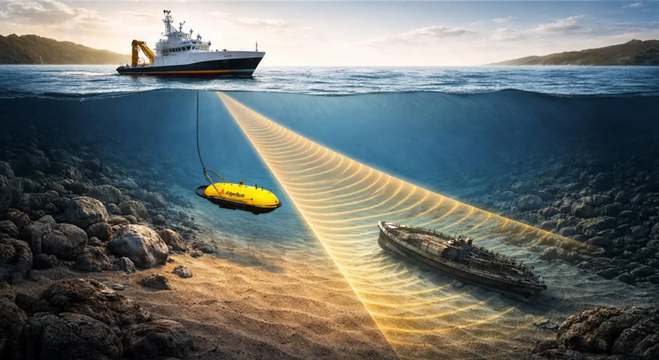
Side scan sonar is an active sonar system that emits sound pulses to both sides of a sensor, typically a towed device known as a towfish. These sound waves reflect off the seabed and objects, and the returning echoes are processed into detailed, image-like representations of the seafloor.
It is one of the most commonly used geophysical survey tools in offshore, marine, and subsea inspection operations.
Unlike traditional echo sounders that measure depth, side scan sonar focuses on visualizing seabed features, making it ideal for detecting:
- Debris and wrecks
- Boulders and obstructions
- Pipelines and cables
- Seabed textures and scours
What is Side Scan Sonar used for?
Side scan sonar is used to support seabed mapping, underwater object detection, route planning, hazard identification, and inspection operations across offshore projects. It is commonly deployed before construction, during survey campaigns, and in search and recovery missions where visual detail of the seabed is critical.
How Side Scan Sonar Works
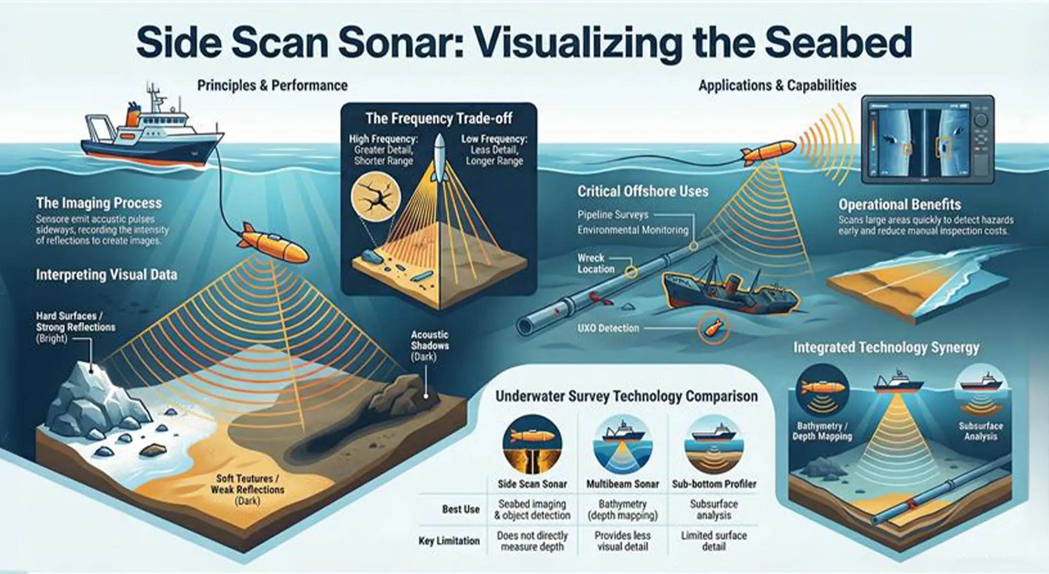
- Sound Transmission: The system emits acoustic pulses sideways across the seabed.
- Echo Reception: Reflected signals return to the sensor and are recorded based on their intensity.
- Image Formation: These signals are processed into sonar images where bright areas indicate strong reflections (hard surfaces or objects and dark areas represent weak returns or acoustic shadows.
- Object Detection Through Shadows: Operators interpret object shape and height using the target reflection and the length of its acoustic shadow.
The infographic below provides a visual overview of how side scan sonar works, including signal transmission, image formation, and key operational use cases.
Side scan sonar is often used alongside multibeam and sub-bottom profilers to provide a complete understanding of seabed conditions.
Key Performance Factors of Side Scan Sonars
- Frequency vs Range:
- Low frequency → Longer range, lower detail
- High frequency → Higher detail, shorter range
- Towfish Altitude: Maintaining the correct height above the seabed ensures consistent coverage and better image quality.
- Survey Speed: Stable speed improves data clarity and reduces distortion in the final imagery.
Advanced Technologies Improving Performance
CHIRP Processing
Modern systems use CHIRP technology to enhance image resolution and improve signal clarity over longer ranges.
Multi-Pulse Capability
Multi-pulse capability allows the system to collect data efficiently at higher survey speeds while maintaining consistent seabed coverage, improving productivity during large-area survey operations.
Side Scan Sonar Solutions from Unique Group
Unique Group offers a comprehensive range of side scan sonar systems and accessories designed to support offshore survey operations.
EdgeTech 4200 MP Dual Frequency Towfish
A highly versatile towed system suitable for both shallow and deep-water surveys. It supports dual-frequency operation and Full Spectrum CHIRP technology, delivering high-resolution imagery across varying ranges. Its multi-pulse capability enables faster survey speeds without compromising data quality, making it ideal for large offshore projects.
EdgeTech 6205 Combined Bathymetry and Side Scan Sonar
This advanced system combines side scan sonar with swath bathymetry, allowing simultaneous collection of imagery and depth data. It enables real-time 3D seabed mapping and reduces the need for multiple survey passes, saving both time and cost in offshore operations.
Designed to improve tow stability and depth control, these depressors allow operators to maintain optimal positioning of the towfish even at higher speeds or greater depths.
Chesapeake SonarWiz Processing Software
A powerful processing solution used to correct, analyze, and mosaic sonar data. It helps transform raw acoustic data into clear, georeferenced images and actionable insights for offshore decision-making.
Typical Offshore Survey Workflow
A standard side scan sonar survey follows a structured process:
-
- Planning: Define survey objectives, coverage requirements, and detection targets
- Mobilisation: Install equipment, integrate navigation systems, and perform system checks
- Data Acquisition: Conduct survey lines while maintaining consistent speed and altitude
- Processing: Apply corrections and generate sonar mosaics
- Reporting: Deliver georeferenced imagery and identified targets
Applications in Offshore Projects
Side scan sonar is widely used across multiple offshore applications:
- Pipeline & Cable Route Surveys
Detect obstacles and assess seabed conditions before installation - UXO Detection
Identify unexploded ordnance and other hazardous objects - Offshore Construction
Ensure seabed readiness for infrastructure development - Environmental Surveys
Map seabed types and monitor changes over time - Search & Recovery
Locate wrecks, debris, or lost equipment
Why Side Scan Sonar Is Essential?
- Wide Area Coverage: Efficiently scans large seabed areas in a short time
- High-Resolution Imaging: Provides clear visualization of underwater features
- Early Hazard Detection: Helps prevent costly delays and operational risks
- Cost Efficiency: Reduces the need for extensive manual inspections
- Better Decision-Making: Supports accurate planning and safer offshore execution
Side Scan Sonar vs Multibeam and Sub-bottom Profilers
| Technology | Best Use | Limitation |
| Side Scan Sonar | Seabed imaging & object detection | Does not directly measure depth |
| Multibeam Sonar | Bathymetry (depth mapping) | Less visual detail |
| Sub-bottom Profiler | Subsurface analysis | Limited surface detail |
In most offshore projects, these technologies are used together for a complete understanding of seabed conditions.
Limitations of Side Scan Sonar
While highly effective, side scan sonar has certain limitations:
- Does not provide direct depth measurements (requires multibeam for bathymetry)
- Interpretation of sonar imagery requires experienced operators
- Performance can be affected by seabed conditions and water column noise
- Objects buried beneath the seabed cannot be detected (requires sub-bottom profiling)
For this reason, side scan sonar is often used in combination with other survey technologies.
Key Considerations When Choosing a System
- Required detection resolution
- Water depth and survey conditions
- Coverage speed and efficiency
- Need for integrated bathymetry
- Data processing and reporting requirements
Conclusion
Side scan sonar remains one of the most essential technologies for offshore seabed imaging and underwater object detection. When combined with the right equipment, proper survey planning, and advanced processing tools, it enables safer, faster, and more cost-effective offshore operations.
With solutions like the EdgeTech 4200, EdgeTech 6205, and supporting technologies available through Unique Group, offshore teams can achieve high-quality results with greater confidence and efficiency.


")


