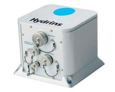
Exail Hydrins: Inertial Navigation System
Hydrins is a high-performance inertial navigation system optimised for hydrographic surveys using multibeam echosounders. Hydrins comprises a single compact unit and delivers highly accurate real-time position, heading, attitude and speed data.

Hydrins is a high-performance inertial navigation system optimised for hydrographic surveys using multibeam echosounders. Hydrins comprises a single compact unit and delivers highly accurate real-time position, heading, attitude and speed data.
Features
All-in-one high-accuracy 3D positioning with heading, roll and pitch
Smart HeaveTM
Automatic GPS drop-out / multipath management
Advanced post-processing software solutions (Delph INS)
Compact, uses any kind of GPS (single antenna)
Specifications
| Availability |
|---|
Dimensions (L x W x H): 180 x 180 x 162 mm
Weight: 4.5 kg
Waterproof: IP66
Operating / storage temperature: -20°C to 55°C / -40°C to 80°C
Rotation rate dynamic range: Up to 750 deg/s
Applications
Multibeam survey
Hydrographic survey
Harbours and inland waterways