The offshore survey industry is changing how data is collected across marine, nearshore and offshore environments. Unmanned Surface Vessels, or USVs, are increasingly being used to support hydrographic and geophysical survey operations by enabling remote or autonomous data collection without crew onboard the vessel.
USVs can help improve operational safety, reduce offshore personnel exposure and support more efficient survey workflows, depending on the project scope, operating environment, payload configuration and regulatory requirements. Their ability to integrate survey sensors such as multibeam echosounders, side scan sonar, sub-bottom profilers, magnetometers and positioning systems makes them valuable platforms for a wide range of marine survey applications.
This article provides a technical overview of USV technology for offshore survey, including common sensor payloads, key application areas, operational considerations and factors that influence platform selection.
What Is an Unmanned Surface Vessel?
An Unmanned Surface Vessel is a watercraft that operates on the sea surface without crew onboard. It can be remotely controlled by an operator, follow pre-programmed survey lines, or use onboard autonomy systems to support navigation and mission execution.
USVs are available in different sizes and configurations, from compact portable platforms to larger vessels designed for extended survey operations. For hydrographic and geophysical survey work, the selected platform must be suitable for the required sensor payload, endurance, communications setup, sea conditions and launch and recovery method.
The term Autonomous Surface Vehicle, or ASV, is sometimes used alongside USV. In general, ASV refers to a vessel with a higher level of autonomous decision-making, while USV is commonly used as a broader industry term covering both remotely operated and autonomous surface platforms.
Key Sensors Used on Survey USVs
Multibeam Echosounders
A multibeam echosounder, or MBES, is one of the main sensors used for bathymetric mapping. It measures water depth and seabed topography by transmitting multiple acoustic beams across a wide swath of the seabed.
On a USV, an MBES is typically hull-mounted and integrated with positioning, motion compensation and sound velocity systems. The quality of the data depends on the echosounder, vessel stability, mounting arrangement, calibration, water depth, sea conditions and survey speed.
When correctly integrated and operated within suitable conditions, USV-mounted MBES systems can support high-quality bathymetric data collection for applications such as seabed mapping, route surveys, harbour surveys and offshore site investigations.
Side Scan Sonar
Side scan sonar is used to produce acoustic images of the seabed surface. It helps identify seabed features such as sediment changes, boulders, debris, pipelines, cables, anchors and other objects.
Many side scan sonar systems are towed behind a survey platform, although some compact or integrated systems can be configured differently depending on the vessel and application. When used with USVs, side scan sonar integration must consider tow cable management, water depth, vessel speed, positioning accuracy and safe deployment and recovery.
Side scan sonar is commonly used in seabed clearance surveys, pipeline and cable route surveys, offshore wind site investigations and general seabed inspection work.
Sub-Bottom Profilers
Sub-bottom profilers, or SBPs, use acoustic energy to image layers beneath the seabed. They are used to support seabed characterisation, identify shallow geological features and detect buried objects or infrastructure where conditions allow.
For USV operations, hull-mounted or compact SBP systems may be suitable depending on the platform, frequency range, penetration requirement and survey objective. Parametric sub-bottom profilers can be particularly useful where a narrow acoustic beam and compact integration are required.
SBP data can support early-stage seabed assessment for offshore infrastructure, cable routes, pipeline routes and marine construction projects. However, it is normally used alongside other geophysical and geotechnical data rather than as a standalone basis for final engineering decisions.
Magnetometers
Magnetometers are used to detect ferrous metallic objects on or below the seabed. These may include buried pipelines, anchors, unexploded ordnance, debris and other metallic features.
USV-based magnetometer surveys require careful consideration of sensor position, magnetic interference from the vessel, tow distance, altitude above seabed and positioning accuracy. Depending on the platform and survey environment, magnetometers may be towed or integrated using a dedicated deployment arrangement.
Magnetometer data is often used in offshore wind, subsea cable, pipeline, dredging and marine construction projects where detection of metallic objects is required before installation or seabed intervention work.
GNSS and Inertial Navigation
Accurate positioning is essential for survey data quality. USVs used for hydrographic and geophysical survey are typically integrated with GNSS, inertial navigation systems, motion reference units and heading sensors.
Where RTK corrections or other suitable positioning corrections are available, USVs can support high-accuracy positioning for survey operations. Motion sensors help compensate for roll, pitch and heave, which is especially important for acoustic systems such as MBES.
The final accuracy of a USV survey depends on the complete integration of the positioning system, sensor offsets, calibration, environmental conditions and data processing workflow.
Key Applications of USVs in Offshore Survey
Offshore Wind Site Investigation
Offshore wind developments require large volumes of seabed and sub-seabed data during planning, design, installation and maintenance stages. USVs can support offshore wind survey campaigns by collecting bathymetric, seabed imagery, sub-bottom and magnetic data, depending on the required payload configuration.
They are particularly useful for repetitive survey lines and areas where reduced vessel size, remote operation or lower personnel exposure can provide operational benefits. USVs may be used as standalone survey platforms or as part of a wider survey spread that includes crewed vessels, ROVs and other marine assets.
Pipeline and Cable Route Surveys
Pipeline and cable route surveys often require a combination of bathymetry, side scan sonar, sub-bottom profiling and magnetometer data. These surveys help assess seabed conditions, route suitability, possible obstructions and existing infrastructure along the proposed route.
USVs can be effective for straight-line transect work and repeatable survey patterns. Their suitability depends on route length, water depth, environmental conditions, communication range, regulatory approval and the sensor payload required.
Harbour, Port and Nearshore Surveys
Harbours, ports, approach channels and nearshore areas often require high-resolution bathymetric data close to structures, shallow areas and restricted-access zones. Compact USVs can be useful in these environments due to their shallow draught, manoeuvrability and ability to operate where larger survey vessels may be less practical.
Typical applications include maintenance dredging surveys, berth inspections, channel surveys, breakwater surveys, infrastructure inspection and environmental monitoring.
Post-Installation and As-Built Surveys
After the installation of subsea infrastructure, offshore structures, cables, pipelines or foundations, survey data is often required to confirm as-laid or as-built conditions. USVs can support these surveys by following repeatable lines and collecting consistent datasets for comparison over time.
They may also be used for periodic monitoring, seabed change detection and asset integrity support, depending on the required data type and operating environment.
Regulatory and Operational Considerations
The regulatory framework for USV operations varies by country, operating area and vessel type. In many cases, USVs are expected to operate in accordance with relevant maritime rules, including collision avoidance requirements, vessel lighting, lookout arrangements and communication procedures.
Operators may use a combination of onboard sensors such as AIS, radar and cameras, along with remote human supervision, to support safe navigation and situational awareness. The level of autonomy, communication range and operator oversight required will depend on the project and local regulations.
For operations in territorial waters, ports, harbours or Exclusive Economic Zones, additional permissions, notifications or operating restrictions may apply. Project teams should confirm local requirements before mobilisation.
Classification societies and maritime authorities continue to develop guidance for autonomous and remotely operated vessels. As these frameworks mature, USV operations are expected to become more standardised across offshore and nearshore survey projects.
Factors to Consider When Selecting a Survey USV
Selecting the right USV depends on the survey objective, site conditions and sensor requirements. Important factors include:
- Required payload and sensor integration
- Vessel endurance and power availability
- Operating area and communication range
- Sea-state and weather limitations
- Launch and recovery method
- Data quality requirements
- Regulatory approval requirements
- Availability of remote operation and support systems
- Compatibility with existing survey workflows
A compact USV may be suitable for harbour, port, inland water and nearshore surveys, while larger USV platforms may be required for longer-duration offshore operations or heavier payloads. The best platform is usually the one that matches the survey scope, environmental conditions and data deliverables without adding unnecessary operational complexity.
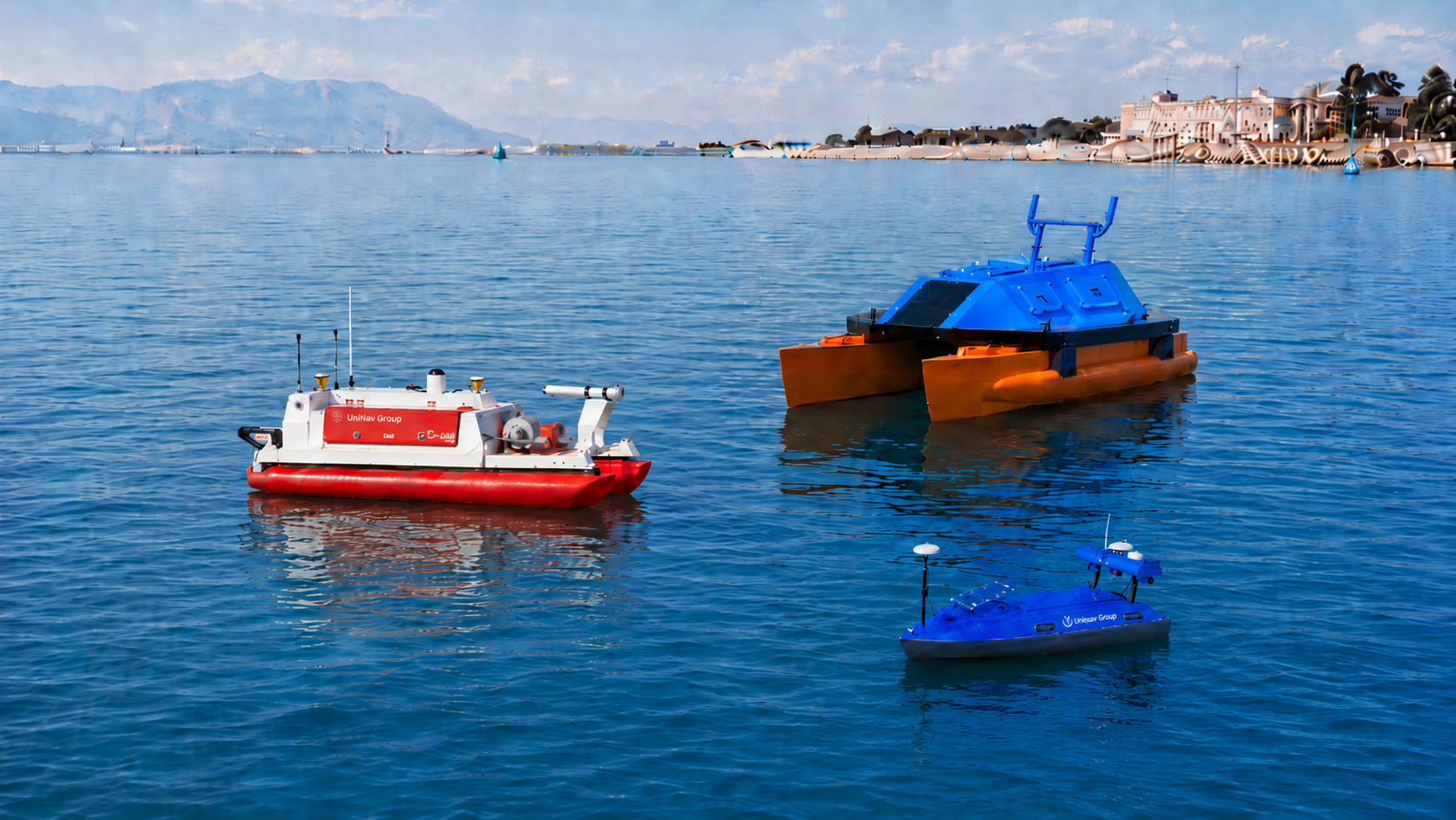
Unique Group’s USV Portfolio
Unique Group offers a range of Unmanned Surface Vessels for survey applications, including Uni-Mini, Uni-Pact, Uni-Max and OPT:WAM V platforms.
These USVs can be configured for different hydrographic and geophysical survey requirements, with integration options for sensors such as multibeam echosounders, side scan sonar, sub-bottom profilers, magnetometers and positioning systems.
The Uni-Mini and Uni-Pact are compact, configurable platforms suited to projects where portability, manoeuvrability and rapid deployment are important. The Uni-Max is designed for larger survey requirements where higher payload capacity, longer endurance or more demanding operational needs may be required. OPT:WAM V provides a further option for hydrographic survey applications requiring a different platform configuration.
Unique Group supplies USV solutions for sale and rental, supported by its wider survey equipment portfolio and technical expertise in marine survey operations.
Conclusion
Unmanned Surface Vessels are becoming an important part of modern hydrographic and geophysical survey operations. They can support safer, more efficient and more repeatable data collection across offshore, nearshore, harbour and inland water environments.
Their value depends on selecting the right platform, integrating the correct sensors and operating within suitable environmental and regulatory conditions. As sensor integration, autonomy and maritime regulations continue to develop, USVs are expected to play an increasing role in offshore survey and marine data acquisition.
Speak with our survey specialists to discuss your project requirements.


")


